Extractos del catálogo

Soil Information ™ System (SIS) Reports TRANSFORMING THE WAY THE WORLD WORKS
Abrir la página 1 del catálogo
Trimble® Ag Software Trimble - CSU ARDEC - Bee Pivot Aspect Data Collection Date: 4/11/2014 azimuth direction The results displayed in SIS maps are dependent on third party data sources. Trimble Navigation Limited hereby disclaims all warranties of any kind regarding the SIS map content or usage, whether express or implied, statutory or otherwise, including but not limited to any warranties of merchantability and fitness for particular purpose. Powered by TCPDF (www.tcpdf.org)
Abrir la página 2 del catálogo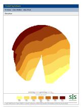
Data Collection Date: 4/11/2014 feet The results displayed in SIS maps are dependent on third party data sources. Trimble Navigation Limited hereby disclaims all warranties of any kind regarding the SIS map content or usage, whether express or implied, statutory or otherwise, including but not limited to any warranties of merchantability and fitness for particular purpose.
Abrir la página 3 del catálogo
Trimble® Ag Software Trimble - CSU ARDEC - Bee Pivot Slope Data Collection Date: 4/11/2014 % The results displayed in SIS maps are dependent on third party data sources. Trimble Navigation Limited hereby disclaims all warranties of any kind regarding the SIS map content or usage, whether express or implied, statutory or otherwise, including but not limited to any warranties of merchantability and fitness for particular purpose. Powered by TCPDF (www.tcpdf.org)
Abrir la página 4 del catálogo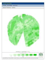
Trimble - CSU ARDEC - Bee Pivot Horizon Thickness - Surface SIS 18 - 20 20 - 22 22 - 24 24 - 26 26 - 28 inches The results displayed in SIS maps are dependent on third party data sources. Trimble Navigation Limited hereby disclaims all warranties of any kind regarding the SIS map content or usage, whether express or implied, statutory or otherwise, including but not limited to any warranties of merchantability and fitness for particular purpose. > 28 Soil Information System
Abrir la página 5 del catálogo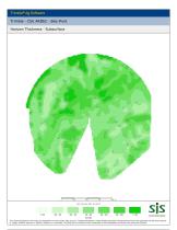
Trimble - CSU ARDEC - Bee Pivot Horizon Thickness - Subsurface SIS Soil Information System inches The results displayed in SIS maps are dependent on third party data sources. Trimble Navigation Limited hereby disclaims all warranties of any kind regarding the SIS map content or usage, whether express or implied, statutory or otherwise, including but not limited to any warranties of merchantability and fitness for particular purpose.
Abrir la página 6 del catálogo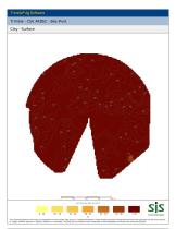
Trimble - CSU ARDEC - Bee Pivot Clay - Surface SIS Soil Information System % The results displayed in SIS maps are dependent on third party data sources. Trimble Navigation Limited hereby disclaims all warranties of any kind regarding the SIS map content or usage, whether express or implied, statutory or otherwise, including but not limited to any warranties of merchantability and fitness for particular purpose.
Abrir la página 7 del catálogo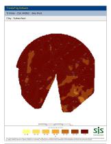
Trimble® Ag Software Trimble - CSU ARDEC - Bee Pivot Clay - Subsurface Data Collection Date: 4/11/2014 % The results displayed in SIS maps are dependent on third party data sources. Trimble Navigation Limited hereby disclaims all warranties of any kind regarding the SIS map content or usage, whether express or implied, statutory or otherwise, including but not limited to any warranties of merchantability and fitness for particular purpose. Powered by TCPDF (www.tcpdf.org)
Abrir la página 8 del catálogo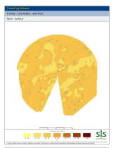
% The results displayed in SIS maps are dependent on third party data sources. Trimble Navigation Limited hereby disclaims all warranties of any kind regarding the SIS map content or usage, whether express or implied, statutory or otherwise, including but not limited to any warranties of merchantability and fitness for particular purpose.
Abrir la página 9 del catálogo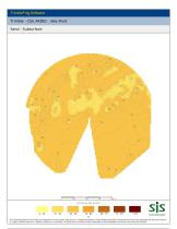
% The results displayed in SIS maps are dependent on third party data sources. Trimble Navigation Limited hereby disclaims all warranties of any kind regarding the SIS map content or usage, whether express or implied, statutory or otherwise, including but not limited to any warranties of merchantability and fitness for particular purpose.
Abrir la página 10 del catálogo
Data Collection Date: 4/11/2014 Clay Clay Loam USDA Texture Classification The results displayed in SIS maps are dependent on third party data sources. Trimble Navigation Limited hereby disclaims all warranties of any kind regarding the SIS map content or usage, whether express or implied, statutory or otherwise, including but not limited to any warranties of merchantability and fitness for particular purpose.
Abrir la página 11 del catálogo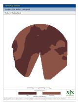
Data Collection Date: 4/11/2014 Clay Clay Loam USDA Texture Classification The results displayed in SIS maps are dependent on third party data sources. Trimble Navigation Limited hereby disclaims all warranties of any kind regarding the SIS map content or usage, whether express or implied, statutory or otherwise, including but not limited to any warranties of merchantability and fitness for particular purpose.
Abrir la página 12 del catálogo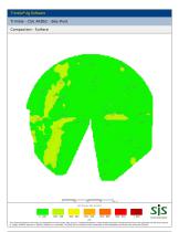
psi The results displayed in SIS maps are dependent on third party data sources. Trimble Navigation Limited hereby disclaims all warranties of any kind regarding the SIS map content or usage, whether express or implied, statutory or otherwise, including but not limited to any warranties of merchantability and fitness for particular purpose.
Abrir la página 13 del catálogo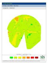
Trimble® Ag Software Trimble - CSU ARDEC - Bee Pivot Compaction - Subsurface Data Collection Date: 4/11/2014 psi The results displayed in SIS maps are dependent on third party data sources. Trimble Navigation Limited hereby disclaims all warranties of any kind regarding the SIS map content or usage, whether express or implied, statutory or otherwise, including but not limited to any warranties of merchantability and fitness for particular purpose. Powered by TCPDF (www.tcpdf.org)
Abrir la página 14 del catálogo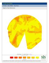
Trimble® Ag Software Trimble - CSU ARDEC - Bee Pivot Depth to Root Restriction Data Collection Date: 4/11/2014 inches @ psi The results displayed in SIS maps are dependent on third party data sources. Trimble Navigation Limited hereby disclaims all warranties of any kind regarding the SIS map content or usage, whether express or implied, statutory or otherwise, including but not limited to any warranties of merchantability and fitness for particular purpose. Powered by TCPDF (www.tcpdf.org)
Abrir la página 15 del catálogoTodos los catálogos y folletos técnicos Trimble Agriculture
-
 NAV-500
1 Páginas
-
 GFX-1060
2 Páginas
-
 GFX-1260
2 Páginas
-
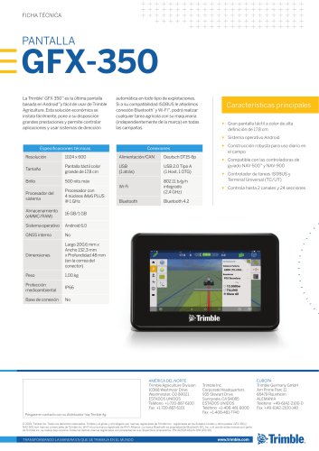 GFX-350
1 Páginas
-
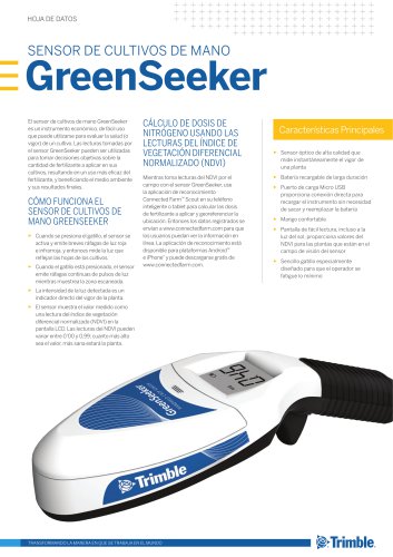 GreenSeeker
2 Páginas
-
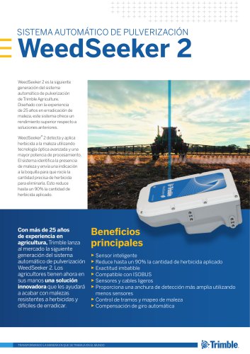 WeedSeeker 2
2 Páginas
-
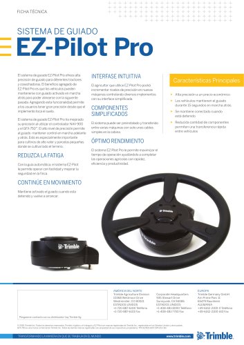 EZ-Pilot Pro
1 Páginas
-
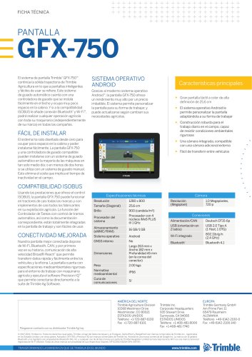 PANTALLA GFX-750
1 Páginas
-
 EZ-Guide 250
2 Páginas
-
 GNSS Correction Sources
2 Páginas
-
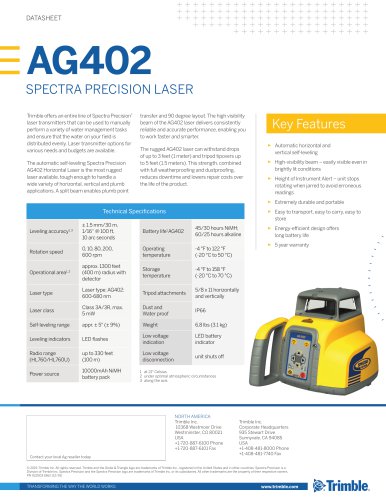 AG402
AG4021 Páginas
-
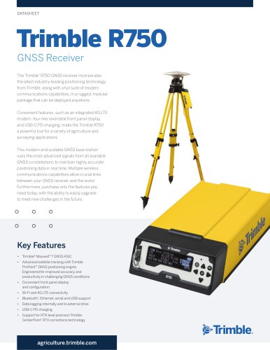 Trimble R750
4 Páginas
-
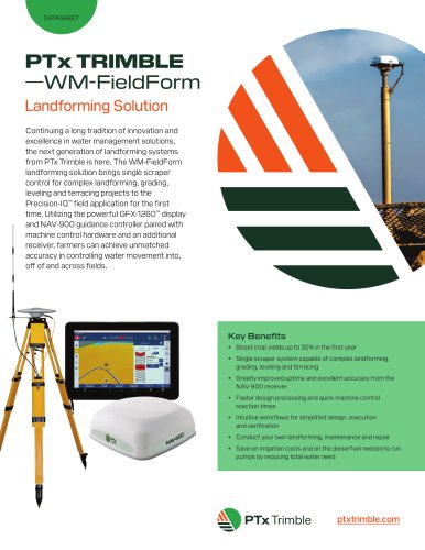 WM‑FieldForm
2 Páginas
-
 NAV-900
1 Páginas
-
 Trimble WM-FormLand Forming Solution
3 Páginas
-
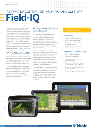
 FIELD-IQ
1 Páginas
-
 Trimble Harvest Solution
4 Páginas
-
 Autopilot
2 Páginas
-
 Trimble Quantm Roads
8 Páginas
-
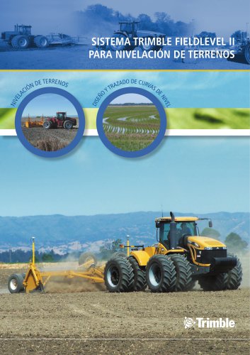
 FieldLevel II Brochure
4 Páginas
-
 WEEDSEEKER SYSTEM
2 Páginas
-
 Field-IQ ISOBUS WEATHER STATION
1 Páginas
-
 RETURN ON INVESTMENT VITICULTURE
9 Páginas
-
 AgGPS
AgGPS6 Páginas
-
 Trimble® Autopilot™
9 Páginas
-
 Trimble® FmX®
524 Páginas
-
 Connected Farm
5 Páginas
-
 FLEET MANAGER
2 Páginas