

EAGLE EYE REPORT

1 / 2 PagesView full catalog
EAGLE EYE REPORT
Product catalog summary
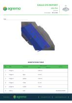
Overview: The document is an Eagle Eye Report dated March 15, 2018, prepared by John Doe. It provides a detailed survey of various agricultural plots and features, including measurements of areas, distances, and specific geographic coordinates.
Annotations Table: The report includes an annotations table that lists various polygons, points, and lines with their respective measurements and coordinates.
Key Sections:
- Polygons: The report identifies several polygons with specific areas measured in square meters. For example, Poligon 1 covers 5343 m², while Poligon 2 covers 1014 m².
- Points: Specific points are marked with latitude and longitude coordinates, such as 'tačka 1 orah' at 45.46534/20.56958.
- Lines: A line labeled 'Linija 1' is noted with a length of 200 meters.
- Additional Features: The report also mentions an orchard with a total area of 5437 m², a field of corn germination covering 4991 m², and a field of winter wheat covering 7374 m².
- Infrastructure: A road is measured at 87 meters, and a water pump is located at 45.46526/20.56960.
Conclusion: The report provides a comprehensive overview of the surveyed agricultural areas, detailing the size and location of various plots and features. This information is crucial for agricultural planning and management.
See more
Catalog excerpts
EAGLE EYE REPORT John Doe Example Survey date: ANNOTATIONS TABLE Title Measurement Area Distance
Open the catalog to page 1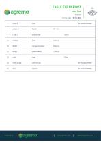
EAGLE EYE REPORT John Doe Example Survey date: dužina reda corn germination winter wheat water pump water pump
Open the catalog to page 2All Agremo catalogs and technical brochures
 PLANT DISEASE ANALYSIS
2 Pages
 CANOPY COVER ANALYSIS
2 Pages
 WATERLOGGING ANALYSIS
2 Pages
 PLANT VIGOR
2 Pages
 FLOWERING ESTIMATOR
2 Pages
 Pest Damage Analysis
2 Pages
 Weed Control Analysis
2 Pages
 Plant Stress Analysis
2 Pages
 Plant Population Analysis
2 Pages
 Stand Count Analysis
2 Pages
*Prices are pre-tax. They exclude delivery charges and customs duties and do not include additional charges for installation or activation options. Prices are indicative only and may vary by country, with changes to the cost of raw materials and exchange rates.