
- Catalogs
- AvMap Navigation
- G7 USER MANUAL

- Products
- Catalogs
- News & Trends
- Exhibitions
G7 USER MANUAL

G7 USER MANUAL
The G7 Farmnavigator is a multifunctional tool designed for agricultural field management. It facilitates mapping, implement setup, guideline creation, and field activity management. Key features include auto-steering, section control, and ISOBUS equipment connectivity. Electrical connections require a 10-35 Vdc power supply with a 2A fuse for protection.
The Turtle Smart antenna is installed using magnets and connects via a 9-pin serial cable. Proper positioning is crucial for optimal performance, considering transverse, longitudinal, height, and orientation axes.
The device is powered on by pressing the power button for 2-3 seconds, with a reset button available for troubleshooting. The multi-touch display supports gestures for navigation and zooming.
The database allows management of drivers, farmers, fields, products, jobs, and implements. New jobs can be started quickly by selecting an implement and defining guidelines, and previous jobs can be resumed directly from the main menu.
Settings include satellite configuration, GPS antenna positioning, auto-steering, ISOBUS, guidance, and user preferences.
Advanced modes allow for creating and modifying A-B lines, connecting external devices, and using the 'Planter' feature for field layouts.
Jobs can be downloaded for office viewing, and field boundaries can be imported in KMZ or SHP formats.
Supports NTRIP configuration for RTK corrections, software updates via WiFi or USB, and video camera connectivity.
Contact information for customer support and an appendix with additional details are provided.
The receiver calculates satellite positions and provides details such as latency, base ID, and estimated error for RTK receivers. Proper operation requires most satellites to be green; otherwise, wait 20 minutes in an open field and clean the antenna.
SBAS enhances accuracy for non-RTK receivers. GLONASS and GALILEO should be ON. BEIDOU is recommended ON for RTK and OFF for non-RTK receivers.
Adjust this value only for RTK receivers after consulting technical support.
Refer to section 2.4.1.1 for details.
This function corrects errors due to tractor inclination. Proper installation and calibration are crucial. Calibrate the tilt sensor on a flat surface to set a new zero reference.
Allows downloading precision corrections for RTK antennas. Requires a GPS antenna connection, internet access, and RTK network access. Ensure all conditions are green for a valid RTK position.
Repeats GPS antenna messages on the generic port for third-party device integration.
Detects tractor movement direction. Use "Run forward" if direction is incorrect.
Configure the antenna's position relative to the tractor's axle and height from the ground.
Access settings for the Auto Steering system. Limited to expert users to avoid malfunctions.
Activates interaction between G7 Farmnavigator and ISOBUS equipment. Requires proper wiring and connection.
Features include displacement amplitude, edge alarm, and synchronization with the generic port.
Edit map view settings, including 2D/3D view, background color, and grid size.
Configure units for area, speed, and distance.
Edit user preferences through the configuration menu.
Configure the remote control for quick access to main functions. Ensure it is within range and properly connected.
Connect to WiFi networks for internet access and updates.
Use the Mirror Control app for remote access via smartphone or tablet.
Check device information and software updates.
Displays job information, connected devices, antenna precision, zoom level, compass, and operational data like area, speed, and distance.
The document is a user manual for the G7 Farmnavigator, detailing its functionalities for agricultural field management. It covers various features such as area marking, guideline creation, field definition, headland management, obstacle marking, auto steering, and advanced operating modes.
The manual explains how to use the START and STOP functions to mark and count worked areas. The START button initiates the marking of a green area, while the STOP button halts the process. These functions are useful during refueling pauses.
Users can create different types of guidelines (A-B Parallel, Contour, Pivot, Adaptive Contour) by marking points A and B. The document provides instructions on saving and managing these lines, including moving, deleting, and listing them.
To define a field, users must trace the perimeter and save it using the FIELD function. The manual outlines steps for editing, viewing, and deleting field boundaries.
This feature helps define the contour of worked areas. Users can set headland width and activate auto steering along the headland path. The manual describes how to enable, disable, and delete headlands.
The G7 Farmnavigator allows users to mark obstacles on the map. This feature is accessible via a remote controller or a specific button, depending on the device model.
The manual details the integration of an auto steering system, which requires an external device. It explains how to enable and disable this feature.
Users can adjust the position of A-B lines by a few centimeters using the NUDGE function. The document provides instructions on setting nudge steps and aligning lines.
The manual describes how to start new jobs, define fields, and create A-B guidelines. It also covers reusing A-B lines with different implements and managing multiple A-B lines within the same job session.
This feature allows users to move A-B lines to the current position of the tractor, useful for avoiding obstacles or adjusting for different implement widths.
The "Street" function allows precise movement of A-B lines from the tractor's current position, essential for maintaining specific distances between lines, creating irrigation streets, and dividing parcels. To use this function, tap "A-B", select the "Street" icon, set the metrical distance, and confirm the movement. The maximum movement is half the implement's width.
The G7 Farmnavigator can connect to external devices like weeders, spreaders, and planters for automatic section control. Connect the device via a 9-pin serial port, create a new implement in the database, select the device type, and configure section widths and delays for opening and closing.
The "Planter" feature helps design planting layouts for vines, fruit plants, and poles. Create a new implement, select "Planter", define row and plant distances, and mark plant positions along A-B lines. The system provides real-time feedback on plant positions and distances.
Jobs can be downloaded in KMZ format for viewing on a PC with Google Earth™. Field boundaries can be imported in KMZ or SHP formats. Create an "Import" folder on a USB stick, copy files, and import them via the G7 Farmnavigator.
NTRIP technology enhances RTK receiver accuracy via internet-based GPS corrections. Configure NTRIP by entering server details and connecting. Ensure the receiver is compatible and connected to the G7 Farmnavigator.
G7 Farmnavigator software updates are available annually via WiFi or USB. For WiFi updates, connect to a network and check for updates. For USB updates, copy the update file to a USB stick and follow the installation procedure.
Connect an analog video camera to the G7 Farmnavigator using the appropriate USB cable. The camera must have a male RCA connector and be powered externally. The camera icon on the main page indicates connection status.
The G7 Farmnavigator includes features such as a camera icon that displays when connected, optional G7 Navi for terrestrial navigation, and the ability to activate a virtual NMEA output on the 'Generic' port for third-party devices. It also offers a Demo mode for demonstrations without GPS and supports firmware updates for AvMap receivers.
To use G7 Navi, insert the AvMap microSD with road maps. For virtual NMEA output, navigate to 'SETUP' > 'Satellites' and enable 'NMEA on Generic port'. To activate Demo mode, go to 'SETUP' > 'System info' > 'Start Demo mode'. Firmware updates are recommended and should not interrupt the device during the process.
First-level assistance covers user manuals, warranty, replacements, malfunctions, repairs, updates, and the MyFarmnavigator.com portal. Second-level assistance includes auto steering, RTK systems, and settings.
The G7 Farmnavigator is compatible with various antennas, sprayers, spreaders, planters, and seeders, including models from FARMNAVIGATOR, Novatel, Agral, Agridrive, and others.
An analytic index provides quick reference to topics such as antennas, auto steering, demo mode, customer support, and more.
Catalog excerpts

USER MANUAL Updated to 3.16.xR software version (where x indicates all 3.16 software versions)
Open the catalog to page 1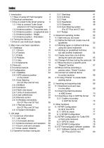
Index 1. Introduction 4 1.1 Ways of using G7 Farmnavigator 4 1.2 Electrical connections 4 1.3 How to install Turtle Smart antenna 5 1.3.1 How to connect Turtle Smart antenna to G7 Farmnavigator 5 1.3.2 Antenna position - Transverse axis 5 1.3.3 Antenna position - Longitudinal axis 5 1.3.4 Antenna position - Height 6 1.3.5 Antenna position - Orientation 6 1.4 Turning the device on 6 1.5 How to use multi-touch display 8 2. Main menu and basic operations 2.1 Database 2.1.1 Drivers 2.1.2 Farmers 2.1.3 Fields 2.1.4 Products 2.1.5 Jobs 2.1.6 Implements 2.2 New job 2.3 Continue last job 2.4 Configuration...
Open the catalog to page 2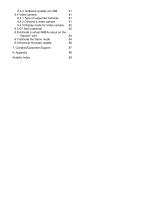
6.3.2 Software Update via USB 6.4 Video camera 6.4.1 Type of supported cameras 6.4.2 Connect a video camera 6.4.3 Display mode for Video camera 6.5 G7 Navi (optional) 6.6 Activate a virtual NMEA output on the “Generic” port 6.7 Activate the Demo mode 6.8 Receiver firmware update Analytic Index
Open the catalog to page 3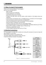
1. Introduction 1.1 Ways of using G7 Farmnavigator Thank you for choosing AvMap G7 Farmnavigator! Now you have the opportunity to: - Map your fields - Set up and save your implements - Create guidelines for your activities - Save all the activities done in the field - Configure the spray boom and have section control directly on the display during your treatments - Control sections automatically, when a compatible device is connected to G7 Farmnavigator - Import and export you jobs and see them on Google Earth™ - Connect Auto-Steering Kit to take full advantage of driving capabilities - Save...
Open the catalog to page 4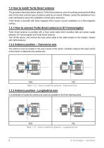
1.3 How to install Turtle Smart antenna The procedure described below refers to Turtle Smart antenna, since it is entirely produced by AvMap and it is the most common type of antenna used by our clients. (Please, contact the assistance if you need clarifications about the installation of third-party antennas). Turtle Smart is provided with three magnets which ensure a quick installation on a ferromagnetic surface. 1.3.1 How to connect Turtle Smart antenna to G7 Farmnavigator Turtle Smart antenna is provided with a 9-pin serial cable which transfers data and power supply between G7 Farmnavigator...
Open the catalog to page 5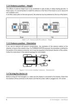
1.3.4 Antenna position – Height The effects of antenna height have to be considered in case of jobs on steep sloping grounds. In these cases, it is recommended to install the antenna on the front of the tractor so as to reduce tilt and oscillation error. In all other cases (jobs on the level ground), the antenna may be positioned on the top of the tractor. Table 1.3.4 - How to install the antenna – Height 1.3.5 Antenna position - Orientation If you use an antenna with ground compensation, the orientation of the antenna relative to the direction of travel of the vehicle is key. For FARMNAVIGATOR...
Open the catalog to page 6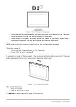
Figure 1.4.a - Turning on the display 1. Press and hold the button located in the upper right corner of the display for 2 to 3 seconds; 2. Once the device is on, the logo will be displayed on the screen; 3. Once loading is completed, a warning section will appear on the screen. Please, read it carefully and press OK to accept and continue, and open the main menu. NOTE: when turning the device on for the first time, you must select the language. To turn the display off: 1. Press and hold the power button for 2 to 3 seconds; 2. Press “YES” to turn the device off. It is possible to reset G7 Farmnavigator...
Open the catalog to page 7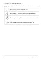
1.5 How to use multi-touch display G7 Farmnavigator is provided with a multi-touch display which allows you to perform specific actions with your fingers. Tap the screen to select a button from the menu. Move your finger to scroll through the menu or scroll through the pages. Slide the fingers closer together or further apart to zoom in or zoom out the field. Touch the screen with two fingers simultaneously to rotate the field. Table 1.5 - Touch screen gestures and movements G7 Farmnavigator – User Manual
Open the catalog to page 8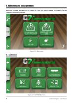
2. Main menu and basic operations Below are the basic operations for the creation of a new job, system settings, the creation of a new implement and working methods. Figure 2.0 - Main menu Figure 2.1 - DATABASE menu 9 G7 Farmnavigator – User Manual
Open the catalog to page 9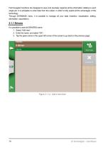
Farmnavigator functions are designed to save and precisely organize all the information relating to each single job. It is advisable to enter data from the outset, in order to fully exploit all the advantages of this technology. Through DATABASE menu, it is possible to manage all your data (insertion, visualization, editing, elimination, exportation). 2.1.1 Drivers It is possible to save all DRIVERS name. 1. elect “Add new”; S 2. nter the name, and select “OK”; E 3. Tap the green arrow in the upper left corner of the screen to go back to the previous page.
Open the catalog to page 10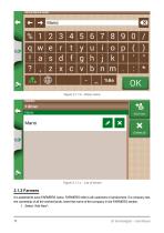
Figure 2.1.1.b - Driver name Figure 2.1.1.c - List of drivers 2.1.2 Farmers It is essential to save FARMERS name. FARMERS refer to all customers or landowners. If a company has the ownership of all the worked lands, insert the name of the company in the FARMERS section. 1. Select “Add New”;
Open the catalog to page 11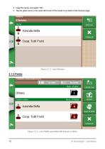
2. nsert the name, and select “OK”; I 3. Tap the green arrow in the upper left corner of the screen to go back to the previous page. Figure 2.1.2 - List of farmers Figure 2.1.3 - List of fields associated with farmers or others
Open the catalog to page 12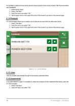
It is possible to collect and save all the parcels of land worked or that must be worked. FIELD are associated with FARMERS: 1. Select farmer name; 2. elect “Add New”; S 3. nsert the name, and select “OK”; I 4. Tap the green arrow in the upper left corner of the screen to go back to the previous page. 2.1.4 Products G7 Farmnavigator allows you to create a list of products and save their use after each activity. 1. Select “Add New”; 2. Insert the name, and select “OK”; 3. Tap the green arrow in the upper left corner of the screen to go back to the previous page. Figure 2.1.4 - List of products...
Open the catalog to page 13All AvMap Navigation catalogs and technical brochures
 4G agri
2 Pages
 g7Farmnavigator
4 Pages
 FARMNAVIGATOR Product Line
16 Pages
 All in One RTK
2 Pages
 G7 Dataseed USER MANUAL
32 Pages

- GNSS receiver
- Digital control system
- Crop input control system
- Spraying control system
- Automated auto steering kit
- Touch screen control system
- Seeding control system
- Agriculture machine auto steering kit
- Tractor auto steering kit
- ISO 11783 control system
- Fertilizer application control system
- Harvesting control system
- GSM receiver
- Multifunction telemetry system
- Steering system receiver