- Catalogs
- CHC Navigation | CHCNAV
- LandStar 8
- Company
- Products
- Catalogs
- News & Trends
- Exhibitions
LandStar 8

LandStar 8
LandStar™ 8 offers a simple and intuitive interface with large map windows and sharp graphics, making it accessible for all users. It allows customization by hiding unused functions and includes integrated video tutorials for quick mastery. Its modular design and rich feature set cater to various applications.
The MetaCAD™ graphics engine enables fast opening and smooth rendering of DWG and DXF base maps, enhancing user experience. It supports large DXF files and includes smart functions like 'Quick Code' for efficient project productivity. Users can edit CAD base maps directly in the field.
LandStar™ 8's cloud-based architecture supports project backup, collaborative work, and data storage. The remote support function provides personalized technical assistance, and the 'Sharing Code' feature facilitates quick data transfer between devices, enhancing work efficiency.
Projects can be initiated swiftly by copying settings via QR code scanning. The app allows easy navigation through project history and properties, and supports dynamic updates of coordinate systems and geoid models. A site calibration wizard simplifies use for non-experts.
LandStar™ 8 integrates comprehensive surveying features for various applications, including construction surveying and GIS data acquisition. It supports industry-standard data formats for seamless integration into existing software environments, ensuring productivity.
LandStar™ 8 supports multiple languages and operates on Android 6.0.1 and higher. It includes features like powerful COGO tools, real-time global TEC maps, and customizable layer management. The app supports various communication protocols and peripheral instruments.
Catalog excerpts

LandStar 8 LAND SURVEYING AND MAPPING APP FOR ANDROID SURVEYING & ENGINEERING
Open the catalog to page 1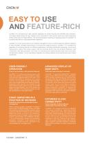
EASY TO USE AND FEATURE-RICH LandStar™ 8 is the field-proven data collection application for Android devices and CHCNAV data controllers. Its modular design allows the user interface to be customized to meet specific needs and make deployment to field crews easy and highly efficient. The advanced graphics rendering of mapping projects in LandStar™ 8 provides users with an unprecedented field experience. LandStar™ 8 is built around easy-to-use workflow management and an intuitive graphical interface designed to help efficiently complete high-precision surveying and mapping projects. LandStar ™...
Open the catalog to page 2
LAND SURVEYING APP FOR ANDROID FEATURE RICH FOR ANY SURVEYING APPLICATIONS
Open the catalog to page 3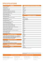
SPECIFICATIONS Communication Protocols Configuration Features Concise user interface Intuitive workflow Embedded e-help-manual Integrated video tutorials Cloud Services / Sharing Code / Remote Tool Connection types (Bluetooth, Wi-Fi and demo) Global Coordinate Systems Library RTCM message support Standard CGD grid/geoid files Supported Languages Site-Calibration wizard Comprehensive import/export format support Differential data relay Chinese (Simplified) Customizable layer management Chinese (Traditional) Convenient Quick Code Automatically connect points into lines Customized WMS/WFS support...
Open the catalog to page 4All CHC Navigation | CHCNAV catalogs and technical brochures
 iBase GNSS RTK Station
4 Pages
 LT700H
4 Pages
 C220GR2
4 Pages
 CGI-610 GNSS/INS SENSOR
4 Pages
 NX510 Pro
4 Pages
 NX510 SE
4 Pages
 DL8 GNSS RTK DATALINK
4 Pages

- GNSS receiver
- Guiding system
- GPS receiver
- GLONASS receiver
- RTK receiver
- GALILEO receiver
- Automated auto steering kit
- Farm machinery antenna
- Tractor auto steering kit
- GNSS auto steering kit
- Wireless receiver
- Agriculture machine auto steering kit
- GNSS antenna
- RTK auto steering kit
- GPS guiding system
- Bluetooth receiver
- UHF receiver
- WiFi receiver
- Guidance receiver
- Combine harvester steering system