


LT700H

LT700H
- GNSS Capabilities: Equipped with a 184-channel GPS, Glonass, Galileo, and BeiDou module, providing centimeter to decimeter accuracy.
- Display: 8-inch IPS sunlight-viewable touch screen with Corning Gorilla Glass 3 for durability and usability in various conditions.
- Performance: Powered by an octa-core 2.2 GHz CPU with 4 GB RAM and 64 GB ROM, expandable via micro SD card up to 256 GB.
- Connectivity: GMS certified, supports 4G modem, dual SIM, Wi-Fi, and Bluetooth 4.1 for seamless communication and data transfer.
- Design: Industrial IP67 rating for dust and water resistance, shockproof from 1.2 m falls, and operational in temperatures from -20°C to +60°C.
- Battery: 8000 mAh Li-ion battery providing up to 12 hours of operation with a 5.5-hour charging time.
- Operating System: Android 8.1 GMS certified.
- Camera: 5 MP front and 16 MP rear cameras with integrated flash.
- Physical Dimensions: 240 mm x 151 mm x 32 mm, weighing 675 g.
- Environmental Tolerance: Humidity range of 5% - 95% RH without condensation.
Catalog excerpts

LT700H RUGGED GNSS RTK TABLET MAPPING & GEOSPATIAL
Open the catalog to page 1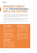
RUGGED TABLET FOR PROFESSIONAL DATA COLLECTION The LT700H RTK Android tablet is designed to increase efficiency and productivity of mobile field workforce in any applications requiring centimeter to decimeter positioning accuracy. Portable, rugged and versatile, the LT700H enables precision GIS data collection, forensic mapping, construction site layout, environmental surveys, landscaping and earthmoving job. Featuring an 8-inch sunlight-viewable screen in direct sunshine and high-bright areas, the LT700H perfectly displays any GIS data tables, complex vector and raster maps or high-resolution...
Open the catalog to page 2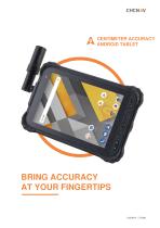
CENTIMETER ACCURACY ANDROID TABLET BRING ACCURACY AT YOUR FINGERTIPS
Open the catalog to page 3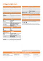
SPECIFICATIONS System Operating system GNSS Accuracies (1) Channel Li-ion battery Battery Life Internal sensors Charging time Display Size NFC; G-Sensor; Light Sensor; E-Compass; Gyroscope 450 cd/m glare resistant, excellent sunlight readable screen Touch Screen Capacitive multi-touch, 10 points Screen technology *All specifications are subject to change without notice. (1) Autonomous and RTK accuracy are based on full GNSS constellations (GPS, Glonass, Galileo and BDS) availability, under clear unobstructed environment, multipath-free, standard satellite geometry andatmospheric conditions. Performances...
Open the catalog to page 4All CHC Navigation | CHCNAV catalogs and technical brochures
 iBase GNSS RTK Station
4 Pages
 C220GR2
4 Pages
 CGI-610 GNSS/INS SENSOR
4 Pages
 NX510 Pro
4 Pages
 NX510 SE
4 Pages
 LandStar 8
4 Pages
 DL8 GNSS RTK DATALINK
4 Pages
- GNSS receiver
- GLONASS receiver
- GPS receiver
- Guiding system
- GALILEO receiver
- RTK receiver
- Automated auto steering kit
- Farm machinery antenna
- Agriculture machine auto steering kit
- Tractor auto steering kit
- Wireless receiver
- GNSS auto steering kit
- GNSS antenna
- RTK auto steering kit
- GPS guiding system
- Bluetooth receiver
- UHF receiver
- WiFi receiver
- Combine harvester steering system
- Guidance receiver