
Catalog excerpts

AVAILABLE ON SOCIAL MEDIA AUTHORIZED DISTRIBUTION PARTNER PRODUCT CATALOG Hi-Target International Group Limited ADD: BLDG 13, Tian'An HQ Center, No.555 North Panyu RD. Donghuan Block, Panyu District, 511400 Guangzhou, China www.hi-target.com.cn +86-20-28688296 sales@hi-target.com.cn ©2023 Hi-Target International Group Limited.
Open the catalog to page 1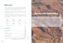
Land survey is one of the indispensable technical means in topographic survey, land monitoring and construction engineering. In order to provide more reliable and effective solutions, Hi-Target focuses on the innovations in GNSS RTK, total station and optical level technologies continuously. Advanced engines, high-precision algorithms and specific surveying technologies are the guarantees for users in the field work. Even in harsh environments, operators can obtain satisfactory measurement results with Hi-Target products. Integrated land survey solutions will greatly improve the quality of...
Open the catalog to page 2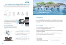
vRTK Visual Positioning Techology Enpowers the New IMU GNSS RTK • Equipped with dual cameras, vRTK is Hi-Target's first lightweight and innovative visual RTK receiver product, which not only enables non-contact image surveying, breaking through the objective constraints of previous work, but also improves the speed of stakeout with the function for Live View Stakeout. It greatly improves the work efficiency for engineering users. Image Positioning Technology The new image survey function achieves non-contact measurement, which greatly enhances the available range of GNSS, realizing more...
Open the catalog to page 3
V500 Compact GNSS RTK with Long Endurance for Accurate Stakeout • Equipped with an upgraded high-definition starlight camera, V500 brings out an excellent visual stakeout experience in low-light conditions. The compact and lightweight design makes V500 a feasible and portable choice for engineering personnel in collecting data and improving positional accuracy. The generated 3D model reveals that the additional images captured by vRTK greatly improve the texture of the building facade, complementing the missing eave elements and tree-shaded building facade modeling from the UAV tilt...
Open the catalog to page 4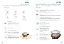
iRTK5 9-axis IMU GNSS RTK • V200 GNSS RTK Receiver brings superior performance and high efficiency to support your fieldwork with reliable solutions. Its deployment of the advanced RTK engine and new-generation IMU guarantees a 25% performance improvement even in the most demanding environments. Thus you can count on Hi-Target V200 for better productivity. - KEY FEATURES Built-in Radio NFC Compatibility with third-party software High Quality Scalable GNSS RTK with HD Touchable OLED Screen Benefiting from the next-generation GNSS engine, unlimited communication technology and innovative...
Open the catalog to page 5
V30 Plus A Simple but not Simplistic GNSS System • iRTK4 is a full-featured, intelligent GNSS receiver system equipped with an integrated new-generation full-frequency antenna and advanced multi-channel engine, allowing users to attain accurate, reliable solutions. Users can also take advantage of calibration-free tilt compensation technology without leveling the survey pole to collect point data in more places. In addition, the Smart Base function in iRTK4 automatically pairs the Rover with the Base by using Hi-Target global servers and ensuring communication by providing the best...
Open the catalog to page 6
Picture Satellite Signal Tracking Cellular Mobile Survey Data Collection Software • Hi-Survey is an Android software that is designed for all types of land survey and road engineering projects in the field. It is compatible with Hi-Target professional controllers, Android phones, tablets and other third-party Android devices. It is a sleek and easy-to-use software that supports the operating of big data with built-in tools. With customized industrial application solutions, more possibilities are created for users. — KEY FEATURES High accuracy and good reliability with various algorithms...
Open the catalog to page 7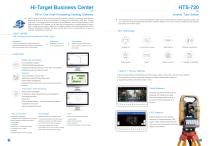
Hi-Target Business Center Field survey GNSS static survey / RTK survey (surveying control). All-in-One Post-Processing Desktop Software HBC, the all-in-one post-processing desktop software, supports processing multi-sourced data from all kinds of surveying equipment, including RTK, total station, UAV, GIS, 3D laser and levels. This one-stop service simplifies the workflow and improves the efficiency of field data processing. HBC enables you to finish the joint-operation on multiple pieces of equipment in projects more easily, helping to fix various problems, like switching between lots of...
Open the catalog to page 8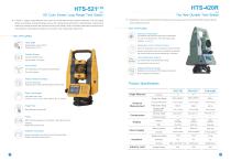
HTS-420R HD Color Screen Long Range Total Station • HTS-5211-10 adopts a high-definition color screen to provide better human-computer interaction. The new optical design and absolute coding technology improve the measurement performance. High-precision compact bead shafting and sealed encoder disk enhance accuracy and stability. Built-in abundant measurement programs and comprehensive maintenance procedures will provide a new measurement experience. The New Durable Total Station • Upgraded by a new accurate EDM and built-in temperature and air pressure sensors, the new HTS-420R is going to...
Open the catalog to page 9
Data Communication Capacity Fast Charge Battery Operation Time Operating temperature Storage temperature TECHNICAL SPECIFICATIONS Product Model Positioning Technology GNSS Feature System Configuration With the development of smart cities, precision agriculture and data visualization, GIS technology begins to play an important role in data acquisition and management. Hi-Target is dedicated to the research and development of portable GIS data collection products, including high-performance GIS handhelds, tablets and mobile GNSS receivers. Compact and rugged design greatly facilitates single...
Open the catalog to page 10
Qmini A10 Pro High-Precision Rugged Tablet • Compact and portable, the Qpad X8 integrates the high-precision GNSS RTK algorithm to provide users with a consumer-grade smart tablet experience for GIS data collection in various industries. It's rugged with exquisite design and structure to achieve industrial-grade protection that can withstand tough environments, greatly facilitates data management and application in the field. - KEY FEATURES High-Precision GIS Handheld Collector (with Intercom Function) • Qmini A10 Pro provides a combination of Galileo positioning, dual-mode intercom, 4G...
Open the catalog to page 11All Hi-target catalogs and technical brochures
-
 iHAND30
2 Pages
-
 FARMSTAR-F2
2 Pages
-
 iHand55
2 Pages
-
 V200
V2002 Pages
-
 vRTK
vRTK4 Pages
-
 V500 GNSS Receiver
2 Pages