albris

albris
- TripleView Camera: Switch between HD and thermal video imagery during flight, capturing high-resolution still images on demand.
- Advanced Situational Awareness: Equipped with five dual-sensor modules and ultrasonic sensors for close-proximity operations and sub-millimeter image resolutions.
- Flight Modes: Offers Autonomous GPS-guided mapping and Interactive ScreenFly modes, with the ability to switch modes during flight.
- Safety and Durability: Features self-monitoring and automated failsafe procedures, shock-absorbent carbon fiber shrouding, and low-noise electric power.
- eMotion X Software: Provides intuitive 3D flight planning, live video feedback, and mission management.
- Mission Blocks: Includes Horizontal Mapping, Around Point of Interest, Panorama, Custom Route, and Cylinder for various applications such as 3D modeling and structural inspection.
- Dimensions: 56 x 80 x 17 cm
- Weight: 1.8 kg including battery and payload
- Flight Time: Up to 22 minutes
- Max Airspeed: 12 m/s in manual flight
- Operating Temperature: -10 to 40º C
- Communication Range: Up to 2 km
Catalog excerpts

The intelligent mapping & inspection drone
Open the catalog to page 1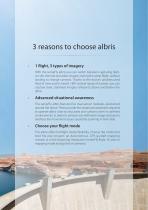
3 reasons to choose albris · 1 flight, 3 types of imagery With the senseFly albris you can switch between capturing highres still, thermal and video imagery during the same flight, without landing to change cameras. Thanks to the drone’s unobstructed field of view and its head’s 180º vertical range of motion, you can capture clear, stabilised imagery ahead of, above and below the albris. Advanced situational awareness The senseFly albris features five dual-sensor modules, positioned around the drone. These provide the situational awareness required to operate albris close to structures and surfaces,...
Open the catalog to page 3
Main camera (HD video & high-res still camera) Thermal camera + edge overlay (video & images) Head navcam (wide-angle video camera)
Open the catalog to page 4
1 flight, 3 types of imagery The senseFly albris is a sensor-rich platform with the widest camera breadth of any civilian drone. Its fully stabilised TripleView camera head allows you to switch between HD and thermal video imagery, live during your flight, plus you can capture highresolution still images on demand. All of this data can be saved for further analysis postflight, and all without landing to change payloads. Main camera (high-res stills/HD video) Thermal camera Headlamp Head navcam Ultrasonic receiver Ultrasonic transmitter TripleView head * 180° vertical range of motion * 6x digital...
Open the catalog to page 5
Advanced situational awareness The senseFly albris is designed from the ground up to perform live inspections of buildings and other structures. Its onboard navcams and ultrasonic sensors provide the visual and proximity feedback you require to take the right decisions and maximise every mission’s chances of success. Ultrasonic sensors Head position Navigate, check for obstacles, keep constant distance from vertical surfaces Navigate, check for obstacles, land autonomously Navigate, check for obstacles, see side views Navigate, check for obstacles, reverse safely
Open the catalog to page 7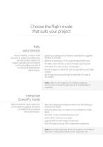
Choose the flight mode that suits your project Fully autonomous Are you looking to map a small site, such as a plant or construction site, directly from above? Or maybe a specific point of interest such as a building or tower? If so, choose an autonomous albris mission. · Specify your area/point of interest in the drone's supplied eMotion X software · eMotion X generates a GPS waypoint-based flight plan · The albris takes off, flies, acquires imagery & lands itself · View albris' live video stream during flight · Record imagery on albris' SD card as required for post-flight analysis · Use image...
Open the catalog to page 9
Live feedback See what albris sees via its wide-angle navcams Instant operation The senseFly albris is ready to fly straight out of its supplied carry case – no construction required Safety smart Numerous self-monitoring & automated failsafe procedures reduce the risk of inflight issues, minimising potential danger to structures, people & the albris airframe Close-object operation Advanced situational awareness and flight stabilisation are enabled by the drone's: · 5 ultrasonic sensors · 5 navcams (visual sensors
Open the catalog to page 10
Onboard albris The senseFly albris is lightweight, shockabsorbent and durable, designed to operate in tight working environments. With its for ward-positioned TripleView camera Electric powered Low noise, no pollution, and easy battery swapping for prolonged use Leading autopilot technology The artificial intelligence built into the senseFly autopilot analyses a raft of data to optimise every aspect of your flight head and open-fronted airframe it offers an unrivalled field of view, while its propellers are fully protected by its advanced carbon fibre shrouding. Bump-safe construction The senseFly...
Open the catalog to page 11
Horizontal Mapping Use this mission block to fly a ‘bird’s eye’, top-down mapping mission (senseFly eBee style). Just set a few key mission parameters, such as your preferred ground resolution, and eMotion X does the rest — creating flight lines and setting GPS waypoints, which are adapted to the terrain, automatically. Around Point of Interest This mission block automatically centres the drone's flight path around a specific point of interest. Once you’ve set the resolution/distance required, eMotion X automatically programs the image capture points. Use this mission block to create a 3D model...
Open the catalog to page 12
Intuitive flight planning & feedback Every senseFly albris is supplied with eMotion X sof t ware, senseFly’s proprietar y f light planning, control and feedback program. Developed specifically for albris, eMotion X is your flight control centre — featuring live streaming video feedback, full control of what imagery albris captures, access to sensor and flight data, plus full flight planning functionality. Choose your mission block Flight planning in eMotion X is simple: just select the pre-programmed mission block that best suits your project. Further advanced mission blocks and software updates...
Open the catalog to page 13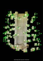
Road bridge pillar inspection, Switzerland
Open the catalog to page 14
Create geo-referenced maps & models After albris lands, simply use eMotion X’s built-in Flight Data Manager to pre-process, geotag and organise its images, before starting image processing. Then use professional image processing software to transform the drone’s images into geo-referenced 2D orthomosaics, 3D building models, 3D point clouds, triangle models, digital surface models and more
Open the catalog to page 15
High-resolution mapping Create high-resolution 2D and 3D maps, or complement fixed-wing drone data by mapping a site’s highly inclined and vertical surfaces 3D modelling Capture high-resolution aerial imagery and transform this into full 3D models of buildings and small/ medium-sized infrastructure Plus… - Crack detection - Bridge, pipe & tower inspection - Plant inspection & documentation - Stockpile assessment - Construction monitoring Inspection Examine and document surfaces and objects—such as bridges, towers, rooftops and cliff faces—in high-resolution - Close agricultural & archaeological...
Open the catalog to page 17All SenseFly catalogs and technical brochures
 eBee
eBee16 Pages