
- Catalogs
- SMAJAYU(SHENZHEN) CO.,LTD
- R26-V2 Survey System


- Company
- Products
- Catalogs
- News & Trends
- Exhibitions
R26-V2 Survey System

R26-V2 Survey System
The R26-V2 survey system is designed for high precision and efficient surveying tasks. It features a compact and portable design, integrating two R26-V2 GNSS receivers and a handheld device with user-friendly surveying software. This system is suitable for various industries including land surveying, construction, forestry, and more.
Key Features
- Supports multiple satellite constellations and frequencies, including GPS, GLONASS, BDS, GALILEO, and QZSS.
- Handheld device equipped with a high-capacity battery for extended outdoor use.
- Intuitive software interface with guided operations for ease of use and increased efficiency.
- Flexible receiver startup and base station connection methods for diverse environments.
- Interchangeable base and mobile stations for versatile surveying applications.
Technical Specifications
- R26-V2 GNSS Receiver and Handheld LP80 specifications are available on the manufacturer's website.
Contact Information
- Website: www.smajayu.com
- Sales Inquiry: [email protected]
- Technical Support: [email protected]
Note: Information and specifications are subject to change without notice.
Catalog excerpts
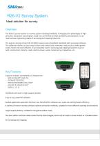
R26-V2 Survey System Ideal solution for survey Overview The R26-V2 survey system is a survey system including Handheld; it integrates the advantages of high precision, low power consumption, small size, convenient and fast portability and operation. It can meet various engineering needs of surveying and mapping industries. The system consists of two R26-V2 GNSS receiver and a Handheld, Handheld with surveying software. The software interface is clear, easy to learn and understand, convenient and practical, making work easier, faster and more efficient. It can be widely used in surveying and mapping industries such as land, construction, forestry, roads, electric power, water conservancy, oil pipelines, etc. Key Features Supports multiple constellations & frequencies: - GPS L1C/A/L2P(Y)/L2C /L5 - GLONASS G1/G2/G3 - BDS B1I/B2I/B3I/B1C/B2a /B2b* - GALILEO E1/E5a/E5b /E6* - QZSS L1, L2, L5 Handbook with built-in high-capacity battery Easy-to-use, powerful software Guided application operation function, low threshold for software use, quick use and high work efficiency A variety of receiver startup and base station connection methods, suitable for more different working environments Large capacity battery, suitable for long time outdoor work The base station and the mobile station can be interchanged, which can be used as a base station or a mobile station for surveying and mapping
Open the catalog to page 1
Signal tracking Precision Index Electrical parameters physical properties Data interface Used guide measurement Channels BDS GPS GLONASS Galileo QZSS Cold start time Initialization time RTK initialization reliability Recapture Point positioning RTK Accuracy Speed accuracy Differential data Location data Static data Power consumption Battery life radio frequency Input voltage Battery capacity Radio station power Storage capacity Operating temperature Storage temperature Physical size Protection grade Impact and vibration: keys Indicators Humidity Weight Data refresh rate Baud rate Interface mode...
Open the catalog to page 2
Website | www.smajayu.com Sales Inquiry | [email protected] Technical Support |[email protected] Information and related materials are subject to change without notice.
Open the catalog to page 3All SMAJAYU(SHENZHEN) CO.,LTD catalogs and technical brochures
 JYB20
JYB205 Pages
 JY305-Operation-Manual_R71
46 Pages
 D30
D301 Page
 601A
601A2 Pages
 D10
D102 Pages
 R30
R302 Pages
 R71
R712 Pages
 R61 NET
3 Pages
 D32
D322 Pages
 R26
R263 Pages
 R26-V2
2 Pages
 R26 Survey System
4 Pages
 JY100 Guidance System
3 Pages


- Crop sprayer
- Self-propelled sprayer
- Digital control system
- GPS receiver
- GLONASS receiver
- Guiding system
- GALILEO receiver
- RTK receiver
- Crop input control system
- Spraying control system
- Automated auto steering kit
- Touch screen control system
- Precision agriculture receiver
- Farm machinery antenna
- Agriculture machine auto steering kit
- Tractor auto steering kit
- Wireless receiver
- GNSS auto steering kit
- GNSS antenna