- Company
- Products
- Catalogs
- News & Trends
- Exhibitions
R26-V2

R26-V2
- Compact design with integrated battery, GNSS antenna, and multiple modules.
- High precision and low power consumption using multi-system, multi-frequency positioning.
- Supports wide voltage range (9~36V DC) with polarity protection.
- IP67 waterproof and dustproof design.
- Bluetooth compatibility with versions 2.0 and 4.0 for differential data transmission.
- Supports CORS connection and various communication protocols, including CSS (Lora).
- Inertial navigation module for tilt measurement and RTK function.
- Interchangeable base and mobile station functionality.
- 8G memory card for real-time data storage.
- Cold start time: < 25 seconds.
- Initialization time: < 5 seconds.
- RTK initialization reliability: > 99.9%.
- Recapture time: < 1 second.
- RTK Accuracy: Flat ±(8 + 1.0 × 10^-6 ×D) mm, Elevation ±(15 + 1.0 × 10^-6 × D) mm.
- Speed accuracy: 0.03 m/s.
- Power consumption: 4.0W (mobile station), 10.5W (reference station).
- Battery life: 18h (mobile station), 11h (base station).
- Radio frequency: 410 ~ 470 MHz / 840 MHz.
- Input voltage: 9~36V DC.
- Battery capacity: 10200 mAh.
- Operating temperature: -45 ℃ to +75 ℃.
- Storage temperature: -55 ℃ to +85 ℃.
- Size: 140mm×141mm.
- Weight: 1.03Kg.
- Protection grade: IP67.
- Impact and vibration resistance: 2m drop.
Catalog excerpts

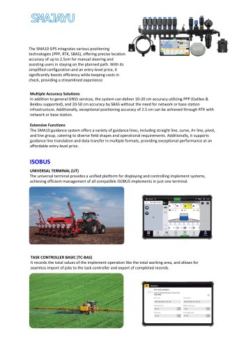
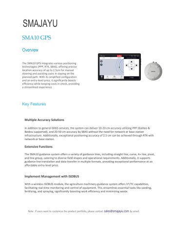
SMAJAYU TECHNOLOGY LIMITED R26-V2 R26 integrated Beidou / GNSS receiver R26 integrated Beidou / GNSS receiver is a built-in large capacity battery, large capacity memory card, integrated multi-function highprecision inertial navigation RTK receiver independently developed by connected navigation, built-in Beidou / GNSS full-frequency antenna, multi-frequency point high-precision positioning and directional board card, Bluetooth, inertial navigation, radio and other modules. R26 receiver can be either RTK mobile station or RTK reference station; high precision, low power consumption, small volume, convenient and quick carrying operation. It can meet the positioning needs of various industries, such as mechanical control, surveying and mapping engineering, precision agriculture, geographic information, water survey, engineering survey, mine survey, aerial photography, unmanned aerial vehicle and so on. Technical Feature • Small volume and high integration, the system can integrate large capacity battery, inertial navigation module, GNSS antenna, satellite positioning module, Bluetooth, radio module, storage module, etc.; • High precision and low power consumption, using Beidou, GPS, GLONASS, Galileo, QZSS and other multi-system multi-frequency system, in a variety of positioning, to ensure the accuracy of complex environment; • Support wide voltage 9~36V DC power supply, with positive and negative polarity reverse connection protection function; • Standard IP67 waterproof and dustproof design; • Built-in Bluetooth module, compatible with 2.0 and 4.0, can send differential data; • Measurement software can realize CORS connection, measuring lofting and other functions; • Built-in integrated radio module supports various communication protocols, such as CSS (Lora) protocol; the maximum transmission power is 2W, can realize the maximum 5 km data communication; • Built-in inertial navigation module, fast calibration, to achieve the inertial navigation RTK function, used for tilt measurement; • The base station and the mobile station can be interchangeable, and can be used as a base station or as a mobile station mapping; • Built-in 8G large-capacity memory card, can be real-time storage of job data. Note: The above information is for reference only and may be varied at delivery. For the latest data, please contact us. Tel: +86-075586276295 Add: Room 213-214, Building 1, Mingliang Science Park, No. 88, Zhuguang North Road, Taoyuan Street, Nanshan District, Shenzh
Open the catalog to page 1
Precision Index presentation of information Electrical parameters physical properties Data interface Used guide measurement BDS GPS GLONASS Galileo QZSS Cold start time Initialization time RTK initialization reliability Recapture Point positioning RTK Accuracy Speed accuracy Differential data Location data Static data Power consumption Battery life radio frequency Input voltage Battery capacity Radio station power Storage capacity Operating temperature Storage temperature Physical size Protection grade Impact and vibration: keys Indicato rs Humidity Weight Data refresh rate Baud rate Interface...
Open the catalog to page 2All SMAJAYU(SHENZHEN) CO.,LTD catalogs and technical brochures
 JYB20
JYB205 Pages
 JY305-Operation-Manual_R71
46 Pages
 D30
D301 Page
 601A
601A2 Pages
 D10
D102 Pages
 R30
R302 Pages
 R71
R712 Pages
 R61 NET
3 Pages
 D32
D322 Pages
 R26
R263 Pages
 R26 Survey System
4 Pages
 R26-V2 Survey System
3 Pages
 JY100 Guidance System
3 Pages


- Crop sprayer
- Self-propelled sprayer
- Digital control system
- Guiding system
- GPS receiver
- GLONASS receiver
- GALILEO receiver
- Crop input control system
- Automated auto steering kit
- Touch screen control system
- Spraying control system
- Precision agriculture receiver
- Farm machinery antenna
- Tractor auto steering kit
- GNSS auto steering kit
- Agriculture machine auto steering kit
- Wireless receiver