
- Catalogs
- Topcon Precision Agriculture
- TAP Satellite Imagery Add-on


- Products
- Catalogs
- News & Trends
- Exhibitions
TAP Satellite Imagery Add-on

TAP Satellite Imagery Add-on
- Satellite imagery aids in timing applications like spraying and harvesting, and supports strategic crop management when combined with data such as soil and yield.
- Different indices are used depending on crop development stages, soil reflectance, and vegetation cover.
- Imagery types include vigor, chlorophyll, and moisture indices, with high-resolution imagery delivered every five days.
- Topcon's technology ecosystem integrates these solutions for seamless data management.
- Vigor Indices: Monitor weed, pest, and disease pressure, irrigation issues, and crop health.
- Chlorophyll Indices: Assess chlorophyll content, crop health, and growth activity.
- Moisture Indices: Detect water stress, irrigation, and drainage issues.
- NDMI: Measures water stress, sensitive to soil reflectance.
- NMDI: Adjusts for soil reflectance to indicate water stress levels.
- TCARI: Indicates chlorophyll content, affected by soil reflectance.
- OSAVI: Adjusts for soil reflectance better than SAVI, useful in sparse canopy conditions.
- NDVI: Driven by photosynthetic activity, sensitive to soil reflectance and moisture conditions.
- Provides tools for high-resolution visualization and data management.
- Includes weather information and field perspective for accurate analysis.
- Offers subscriptions for current and forecasted weather data, crop documentation, and imagery management.
Catalog excerpts

TAP Satellite Imagery Add-onDigital Farm Management FIELDS Management Zone Auto-generated Assign rate Satellite Image Insert rate Zone 2 Insert rate UA. Zone 4 Insert rate Satellite imaging measures crop and field health for relevant insights that lower your risk
Open the catalog to page 1
Imagery types for vigor, chlorophyll and moisture Lower Your Risk with Satellite Imagery High-resolution (10 meter-spatial) imagery delivered every five days Satellite imaging measures crop and field health for relevant insights that lower your risk. Our technology provides active monitoring and a record to track development. Solutions apply indices, in-season or out-of-season to analyze field conditions and aid impactful decisions. You can use satellite imagery to guide key applications throughout the crop cycle, such as spray or harvest timing. It can also support strategic crop management...
Open the catalog to page 2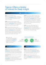
Topcon Offers a Variety of Indices for Deep Insight Vigor (Crop Health) SAVI (Soil Adjusted Vegetation Index) Index driven by plant density; adjusted for soil reflectance and bare soil. Considerations: Adjusts for soil reflectance. OSAVI is better adjusted for soil reflectance in various canopy cover scenarios. OSAVI (Optimized Soil Adjusted Vegetation Index) Index driven by plant density; adjusted for soil reflectance and bare soil. Considerations: Adjusts for soil reflectance, better than SAVI. In situations of no or inconsistent crop canopy density, OSAVI works better than SAVI. NDVI (Normalized...
Open the catalog to page 3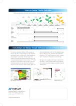
While every growing cycle varies upon conditions, including crop, soil, and weather; this is a general guide. Weak Canopy Strong Canopy High Soil Reflectance Early Mid Late Early Mid Late Maturity Vegetation Vegetation Vegetation Reproductive Reproductive Reproductive SAVI OSAVI NDVI GNDVI WDRVI LAI TCARI TCARI:OSAVI NDMI NMDI The Topcon Agriculture Platform (TAP) provides an easy-to-use tool to analyze imagery in high-resolution visualization layers, including clear data management and navigation functionality. Growth stages and weather information and general field perspective are crucial to...
Open the catalog to page 4All Topcon Precision Agriculture catalogs and technical brochures
 Landforming
2 Pages
 On-Board Weighing TT Weigh
2 Pages
 Digital Farm Management
1 Page
 CROPSPEC
2 Pages
 MAGNET
34 Pages
 TOPCON WORKPLACE
13 Pages
 APOLLO
4 Pages
 MR-2
MR-21 Page
 HORIZON OS
2 Pages
 X35
X352 Pages
 X25 Console Brochure
2 Pages
 X14 Console Brochure
2 Pages
 X Consoles Brochure
4 Pages
 TopNET live Brochure
2 Pages
 CROPSPEC Brochure
2 Pages


- Agriculture software
- Joystick
- GNSS receiver
- On-board multi-purpose instrument
- Tractor multi-purpose instrument
- Digital control system
- Weighing system
- Data management software
- Digital weight indicator
- Analysis software
- RTK receiver
- Multi-purpose instrument with screen
- Digital multi-purpose instrument
- Crop input control system
- Animal husbandry software
- Spraying control system
- Hand operated joystick
- Precision agriculture receiver
- Seeding control system
- CAN-Bus electronic control unit