- Catalogs
- Topcon Precision Agriculture
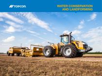
- WATER CONSERVATION AND LANDFORMING
WATER CONSERVATION AND LANDFORMING

WATER CONSERVATION AND LANDFORMING
Topcon provides advanced landforming solutions using GNSS technology, offering dual-constellation satellite reception (GPS + GLONASS) for precise grading. This system allows for efficient surveying and grading over large areas, up to 12,000 acres, and operates continuously in various environmental conditions. The GNSS system enhances accuracy and reduces material movement by up to 10% compared to traditional methods.
The AGI-4 is a modular, ISO-compliant autosteering system that can be upgraded to 2cm accuracy with RTK options. It integrates the antenna, receiver, and steering controller, providing superior line acquisition and holding capabilities. The system is designed for dynamic applications and challenging terrains.
The X30 touchscreen console, combined with the AGI-4 Receiver/Steering Controller, offers simultaneous high-accuracy autosteering and landforming. The console features an intuitive interface with real-time data display, enhancing user experience. The integration with AGForm-3D software provides a comprehensive solution for water conservation and grading.
AGForm-3D software, paired with the HiPer V receiver/base station, allows for efficient field surveying and design without leaving the vehicle. It includes the Variable Slope PWCS module, which optimizes land leveling by minimizing material movement and maintaining design surfaces close to the original terrain.
The HiPer V base station is a user-friendly RTK base station that functions as a mobile or fixed base. The CR-G5 Dome Antenna and MC-R3 Receiver/Controller offer enhanced performance in challenging environments, while the MC-A1 GNSS Antenna provides precision and reduces errors.
Catalog excerpts
TOPCOIX WATER CONSERVATION
Open the catalog to page 1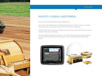
INDUSTRY LEADING LANDFORMING Proven survey, field design and landforming with GNSS accuracy. Topcon offers dual-constellation (GPS + GLONASS) satellite reception for maximum accuracy with single or dual scraper control, plus the ability to grade more than 12,000 acres in a single setup. The GNSS system offers continuous 24/7 operation and can work in wind, dust, fog and other environmental conditions where lasers have challenges. The Topcon GNSS solution allows the operator to survey, create cut/fill maps and start grading without ever leaving the cab. Best-fit calculations reduce yardage up...
Open the catalog to page 3
SIMULTANEOUS AUTOSTEERING The first truly modular ISO-compliant steering system. The AGI-4 comes standard with WAAS and EGNOS, but is easily upgradeable to 2cm accuracy with RTK radio options. Like all Topcon receivers, the AGI-4 offers GNSS multi-constellation satellite reception standard for unmatched accuracy in dynamic applications and terrain conditions. The all-in-one, modular design incorporates the antenna, receiver and steering controller in a single component, offering unmatched upgradeability. AGI-4’s ISO11783 compliant steering system features state-of-the-art inertial sensors and...
Open the catalog to page 5
X30 12.1 in. Touchscreen Console Now, the 12.1” Topcon color touchscreen X30 console, integrated with Horizon software, and teamed with the AGI-4 Receiver/Steering Controller, brings high-accuracy RTK autosteering simultaneous with high-accuracy landleveling or landforming. The X30 Console displays real-time elevation, maps, position and menus in the easiest-to-use console on the market. The X30 is a premium featured console, offering intuitive user interface with icon-based, user-definable, multitouch screen. It offers mini-view drag-and-drop info windows, user definable dashboard, and interactive...
Open the catalog to page 6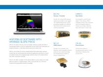
AGFORM-3D SOFTWARE WITH VARIABLE SLOPE PWCS AGForm-3D state-of-the-art survey and design software coupled with HiPer V receiver/base station is used for independent survey of fields and creating flat and single/dual slopes or multi slopes without leaving the vehicle cab. AGForm-3D includes the Topcon Variable Slope PWCS field design software module that has revolutionized land leveling by significantly reducing the volume of material moved and by keeping design surfaces closer to the original terrain than older multi-planar methods. AGForm-3D offers complete control with the ability to survey,...
Open the catalog to page 7
Specifications subject to change without notice. All rights reserved. 7010-2164 B 2/16 ©2016 Topcon Corporation
Open the catalog to page 8All Topcon Precision Agriculture catalogs and technical brochures
 Landforming
2 Pages
 On-Board Weighing TT Weigh
2 Pages
 Digital Farm Management
1 Page
 TAP Satellite Imagery Add-on
4 Pages
 CROPSPEC
2 Pages
 MAGNET
34 Pages
 TOPCON WORKPLACE
13 Pages
 APOLLO
4 Pages
 MR-2
MR-21 Page
 HORIZON OS
2 Pages
 X35
X352 Pages
 X25 Console Brochure
2 Pages
 X14 Console Brochure
2 Pages
 X Consoles Brochure
4 Pages
 TopNET live Brochure
2 Pages
 CROPSPEC Brochure
2 Pages


- Nardi Pegaso agricultural software
- Joystick
- On-board multi-purpose instrument
- GNSS receiver
- Tractor multi-purpose instrument
- Digital control system
- Data management software
- Weighing system
- Digital weight indicator
- Analysis software
- Multi-purpose instrument with screen
- Animal husbandry software
- RTK receiver
- Digital multi-purpose instrument
- Crop input control system
- Hand operated joystick
- Spraying control system
- Precision agriculture receiver
- Seeding control system
- Mapping software