
- Catalogs
- Trimble Agriculture
- FieldLevel II Brochure


FieldLevel II Brochure

FieldLevel II Brochure
The document outlines the capabilities of the Trimble FieldLevel II system, a comprehensive solution for land leveling and levee design to optimize water management in agriculture. It highlights the system's ability to improve yields, reduce water usage, and enhance farm productivity.
Survey
The system uses precision RTK measurements for accurate field mapping, allowing for optimal surface drainage designs. It facilitates the creation of boundaries, interior points, and surfaces, and provides accurate acreage calculations.
Design
Utilizing Autoplane technology, the system creates best-fit surfaces based on surveys, prescribed slopes, and cut and fill balance requirements. It supports complex field requirements through Multiplane design software, ensuring seamless data transfer to the FieldLevel II system.
Leveling
The system automates scraper hydraulic valves to efficiently move dirt across fields, compatible with any tractor and scraper model. It supports tandem and dual scraper systems to enhance productivity.
Levee Design and Installation
The FieldLevel II system offers two methods for rice levee installation: a complete design and guide solution or manual contour guidance. It captures 3D topography data for analysis and optimal levee location determination, utilizing the Trimble Autopilot for automated steering during installation.
Contour Guidance
Manual marking of levees along field contours is facilitated by the system, reducing time and difficulty compared to traditional methods. The Trimble lightbar assists in precise levee marking.
Water Management Benefits
The system is crucial for efficient water use in agriculture, which consumes 70% of the world's fresh water. It supports topographic mapping for cut and fill maps, enhancing water distribution and cost efficiency.
Cross-Functional Utility
Trimble's technology integrates with other agricultural solutions, such as drainage, precision guidance, and yield monitoring, maximizing investment value.
Conclusion
With 25 years of experience, Trimble's water management systems are proven to improve yields by 25% and reduce water usage by 30%, emphasizing the importance of every dollar and drop in agriculture.
Catalog excerpts

Trimble FieldLevel II SYSTEM for Water Management
Open the catalog to page 1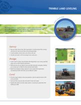
TRIMBLE LAND LEVELING The Trimble® FieldLevel™ II system provides a complete solution for surveying, designing, and leveling field surfaces to ensure optimal water management. It provides vast improvements in yields, water usage, and farm productivity. Survey • Map your fields with precision RTK measurements to provide optimal field coverage and ensure the most accurate field surface drainage designs. • Create boundaries, interior points, and surfaces with ease. • Calculate and report on the true acreage of your survey area. Design • Create a best-fit surface using Autoplane technology based...
Open the catalog to page 2
trimble Levee Levee • Capture 3D topography data using the FieldLevel II Survey and Design module on your FmX® integrated display and import data to Farm Works™ Surface software using the Connected Farm™ or a USB drive. • Analyze the shape of the field using the 3D viewer, contours, flow arrows, and tributary information. • Define the start point, vertical intervals, and turn radius capability of the machinery being used; Surface will determine the best levee locations in the field for optimal water use. • Export the design back to your FmX display using the Connected Farm or a USB drive, and...
Open the catalog to page 3
Water is one of nature’s most precious resources, and one that farmers worldwide must utilize effectively in order to meet the ever-increasing demand for food. The FieldLevel II system is Trimble’s most efficient water management system, utilizing GPS signals for topographic surveying, land leveling, and levee design and installation. As much as seventy percent of the world’s fresh water is used for agriculture purposes. Products like the FieldLevel II system, that can minimize water costs and efficiently distribute water by maintaining grade, are critical for water preservation. In addition,...
Open the catalog to page 4All Trimble Agriculture catalogs and technical brochures
 AG402
AG4021 Page
 Trimble R750
4 Pages
 WM‑FieldForm
2 Pages
 NAV-900
1 Page
 NAV-500
1 Page
 GFX-1060
2 Pages
 GFX-1260
2 Pages
 GFX-350
1 Page
 FIELD-IQ
1 Page
 GreenSeeker
2 Pages
 WeedSeeker 2
2 Pages
 FieldLevel II
2 Pages
 Trimble Harvest Solution
4 Pages
 EZ-Pilot Pro
1 Page
 GFX-750 DISPLAY
1 Page
 Autopilot
2 Pages
 EZ-Guide 250
2 Pages
 Soil Information System™ (SIS)
73 Pages
 Trimble Quantm Roads
8 Pages
 WEEDSEEKER SYSTEM
2 Pages
 AgGPS
AgGPS6 Pages
 Trimble® Autopilot™
9 Pages
 Trimble® FmX®
524 Pages
 Connected Farm
5 Pages
 FLEET MANAGER
2 Pages


- Agriculture software
- GNSS receiver
- On-board multi-purpose instrument
- Tractor multi-purpose instrument
- GPS receiver
- GLONASS receiver
- Guiding system
- Real-time software
- GALILEO receiver
- RTK receiver
- Analysis software
- Digital multi-purpose instrument
- Multi-purpose instrument with screen
- Weather station
- Crop input control system
- Spraying control system
- Automated auto steering kit
- Precision agriculture receiver
- Precision agriculture software
- Crop input controller