
Excertos do catálogo

TOPCOIX WATER CONSERVATION
Abrir o catálogo na página 1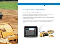
INDUSTRY LEADING LANDFORMING Proven survey, field design and landforming with GNSS accuracy. Topcon offers dual-constellation (GPS + GLONASS) satellite reception for maximum accuracy with single or dual scraper control, plus the ability to grade more than 12,000 acres in a single setup. The GNSS system offers continuous 24/7 operation and can work in wind, dust, fog and other environmental conditions where lasers have challenges. The Topcon GNSS solution allows the operator to survey, create cut/fill maps and start grading without ever leaving the cab. Best-fit calculations reduce yardage...
Abrir o catálogo na página 3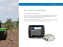
SIMULTANEOUS AUTOSTEERING The first truly modular ISO-compliant steering system. The AGI-4 comes standard with WAAS and EGNOS, but is easily upgradeable to 2cm accuracy with RTK radio options. Like all Topcon receivers, the AGI-4 offers GNSS multi-constellation satellite reception standard for unmatched accuracy in dynamic applications and terrain conditions. The all-in-one, modular design incorporates the antenna, receiver and steering controller in a single component, offering unmatched upgradeability. AGI-4’s ISO11783 compliant steering system features state-of-the-art inertial sensors...
Abrir o catálogo na página 5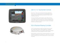
X30 12.1 in. Touchscreen Console Now, the 12.1” Topcon color touchscreen X30 console, integrated with Horizon software, and teamed with the AGI-4 Receiver/Steering Controller, brings high-accuracy RTK autosteering simultaneous with high-accuracy landleveling or landforming. The X30 Console displays real-time elevation, maps, position and menus in the easiest-to-use console on the market. The X30 is a premium featured console, offering intuitive user interface with icon-based, user-definable, multitouch screen. It offers mini-view drag-and-drop info windows, user definable dashboard, and...
Abrir o catálogo na página 6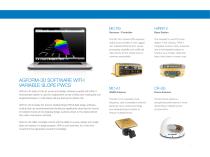
AGFORM-3D SOFTWARE WITH VARIABLE SLOPE PWCS AGForm-3D state-of-the-art survey and design software coupled with HiPer V receiver/base station is used for independent survey of fields and creating flat and single/dual slopes or multi slopes without leaving the vehicle cab. AGForm-3D includes the Topcon Variable Slope PWCS field design software module that has revolutionized land leveling by significantly reducing the volume of material moved and by keeping design surfaces closer to the original terrain than older multi-planar methods. AGForm-3D offers complete control with the ability to...
Abrir o catálogo na página 7
Specifications subject to change without notice. All rights reserved. 7010-2164 B 2/16 ©2016 Topcon Corporation
Abrir o catálogo na página 8Todos os catálogos e folhetos técnicos Topcon Precision Agriculture
-
 Landforming
2 Páginas
-
 Feed Management Software (TAP FEED)
2 Páginas
-
 On-Board Weighing TT Weigh
2 Páginas
-
 Digital Farm Management
1 Páginas
-
 TAP Satellite Imagery Add-on
4 Páginas
-
 CROPSPEC
2 Páginas
-
 MAGNET
34 Páginas
-
 TOPCON WORKPLACE
13 Páginas
-
 APOLLO
4 Páginas
-
 MR-2
MR-21 Páginas
-
 HORIZON OS
2 Páginas
-
 X35
X352 Páginas
-
 YIELDTRAKK HARVEST YIELD MONITORING
4 Páginas
-
 X25 Console Brochure
2 Páginas
-
 X14 Console Brochure
2 Páginas
-
 X Consoles Brochure
4 Páginas
-
 TopNET live Brochure
2 Páginas
-
 CROPSPEC Brochure
2 Páginas